Welcome to a new year of investigating the history of the area surrounding the UNE campus.
Readers of this blog who followed the course last fall will already know that this is an extraordinary area. The history of native people living here extends to the end of the last ice age. This was one of the first points of contact with Europeans. It was among the first areas settled. (Depending on how you define “settled,” you might push the date to before the settlement at Plymouth.) It was the center of Biddeford until ship building, saw mills, and later textile mills moved the center of gravity up river to the falls. It is at that point that the fall 2025 edition of Environmental History of New England picks up.
Last year, Professors Arthur Anderson and Eric Zuelow, leading a superb team of students, investigated the story of a house that once stood in front of what we now call Decary Hall. We came to know it as “The Wayside.” We traced how it went from private residence to shore dinner hall to dorms and classrooms, to being broken into a private home and a masonry business.
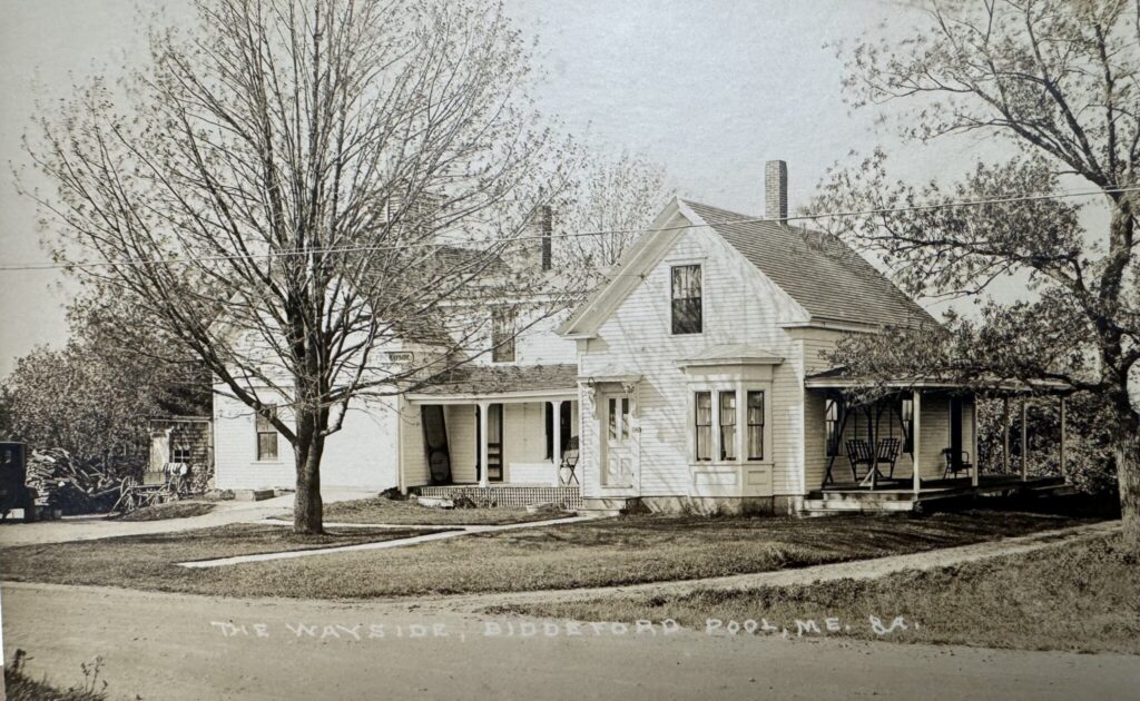
At the crux of that story was the Mitchell/Flood family. The Mitchells were one of the early families to arrive in this area and they established themselves on the banks of the Saco River fishing and doing some farming—a lifestyle we might describe as “farmer/fishermen.” It was a happy enough existence spanning generations.

By the second half of the nineteenth century, though, it was growing increasingly challenging. Alonzo Mitchell, the fellow who built The Wayside, turned his attention to a variety of jobs including shopkeeper and fireman at the mills, among others, before landing on running a shore dinner hall for visiting motor tourists. Farmer/fisherman didn’t pay the bills.
Indeed, one might hypothesize that the old families who settled the banks of the Saco found their old way of life disappearing before them by the second half of the nineteenth century. They needed to adapt. But how? That is one of the key questions that launches us this semester.
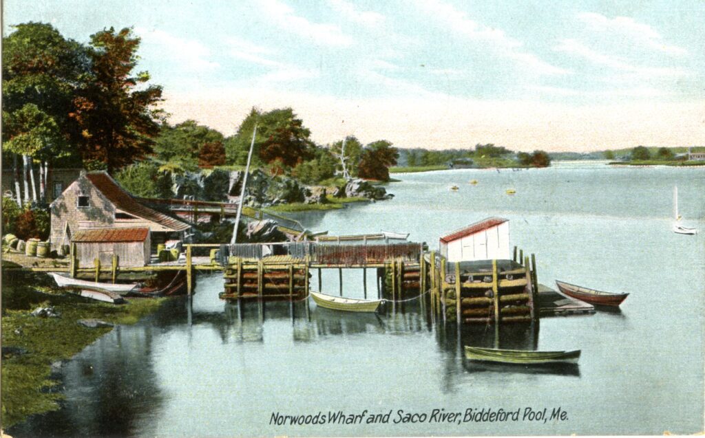
https://digitalcommons.library.umaine.edu/spec_photos/445.
Our investigation begins with a postcard of “Norwoods Wharf.” It appears all over the place. You can buy it on eBay. It turns up in the “Postcard History Series” volume entitled The Saco River by David Robinson and Elizabeth Tanefis. It’s all over Maine history websites. End of the day, it’s one of the more iconic images of the lower Saco River from the turn of the century.
Right off the bat, a mystery needed solving even before the semester started: where exactly was Norwoods Wharf? Robinson and Tanefis write: “This card is titled ‘Norwood’s Wharf and Saco River, Biddeford Pool, ME.’ Biddeford Pool is located at the mouth of the river and was well known as a summer colony for many years. Just out of view and around the bend today is the University of New England, which has conducted a great deal of research on the river” (highlighting is mine).
The problem with this language is that it either implies the wharf was located where “Freddy Beach” and the Marine Science Center now sit, or that UNE is located further up river than it actually is, perhaps in the proximity of Ferry Lane. Neither is the case.
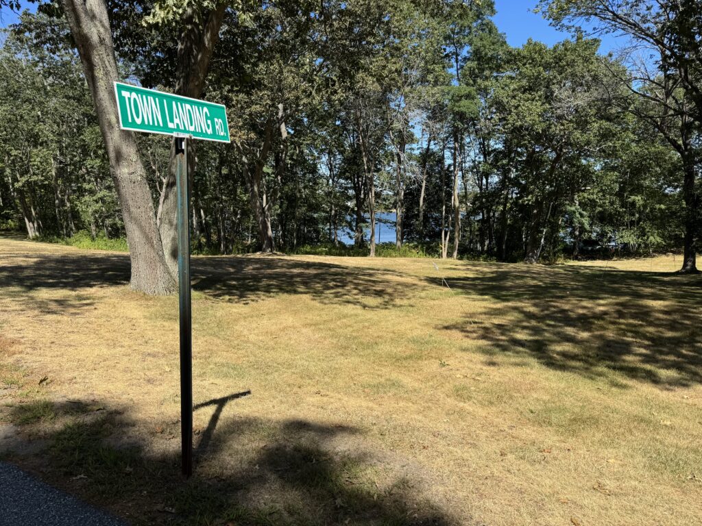
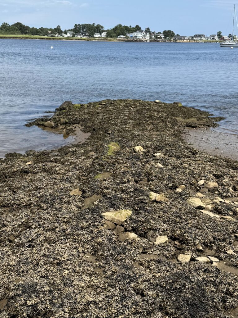
When I first saw the postcard, it was presented to me as an image of the Town Landing, the dock from which the Mitchell family operated, along with many other local peoples. That site is located on the UNE Campus, just downhill. All that remains of that dock is a small bit of visible archaeology and a vestigial road sign.
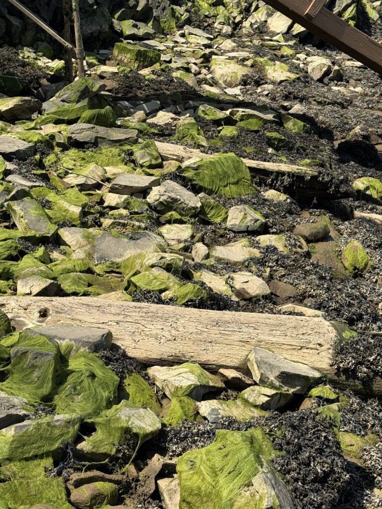
Problem is, it’s a different dock. It’s isn’t Norwoods Wharf. A gander at the surrounding rocks make this pretty clear.
So, I spent some time last spring and into the summer looking for the dock, walking what I could of the beach and peering at the local rocks. Eureka!
A nervous knock on the door, a bit of explaining, and soon I was standing face-to-face with what remains of the piers, bits of concrete, and some visible underwater remains. With the blessing of the kind, friendly, helpful, and fortunately very curious Abby and Bob Haskell, the current landowner’s, we’re going to do an archaeological survey of the site.
While there is relatively little research done before the start of the semester (beyond identifying archives, possible dig sites, etc.) for these courses, it was still important to figure out some rudimentary details. So, in broad brushstrokes, who were the Norwoods? Whose property was the wharf originally on?
It didn’t take long to find out. The dock sat at the base of a property owned by Nelson Norwood (1869-1944). His family arrived in the area in the 1820s, started buying land, and making a living. They were, in short, farmer/fishermen.
Eventually, the Norwoods owned much of the land extending from the Mitchell property to Ferry Lane. It was a large family. There were multiple houses. Two of them were keepers of the light at Wood Island lighthouse, where they also purchased land. They were an important fixture of the area, so much so that a 1922 poem, written by the artist-illustrator James Montgomery Flagg, about the state of the Pool Road used them as a signpost:
Our tires explode right and left in the air
As we bounce through the Valley of Stones
Past the Norwood’s and the Thompson’s we cling to our hair
And we hark to the snapping of bones!
— Dane Yorke, A History of Old Biddeford, 1947. [Republished McArthur Public Library 1994, 2007].
Interestingly, it appears that at least one Norwood attempted to capitalize on the rising status of the area as a tourism hotspot by leading boat tours—the same business that the current landowners, Abby and Bob, continue to this day. Talk about a beautiful continuity.
We need to learn a lot more, but descendants are still in the area and the availability of archival records at both Maine Historical Society and the McArthur Library in Biddeford are super promising.
So, here’s the plan. We’re starting the term with a trip out to the Wood Island Lighthouse. Our trip is being led by the Friends of the Wood Island Lighthouse, a tremendous group of volunteers who maintain the lighthouse and lead summertime tours. They do more. They maintain an archive, field questions, and act as ambassadors for local history. One member of the group, Richard Parsons published a really fantastic history of the lighthouse and the local community, Wood Island Lighthouse: Stories from the Edge of the Sea, that does a beautiful job of storytelling, but also of capturing the realities of life on the edge of America. Such a great book! (More recently, he’s published a work on the Fletcher’s Neck Lifesaving Station that I’m anxious to get my hands on.)
From there, we’ll be doing an archaeological survey of the wharf, sailing up the river to learn what we can, trolling through archives, and finally delivering a podcast series in December. I’ll be documenting it all here, so get on your lifejackets and stay tuned!
— Prof. Eric G. E. Zuelow